
Bikepacking Cathedral Valley
Cathedral Valley bikepacking
The Cathedral Valley is a colourful, dusty and beautiful bikepack into one of Southern Utah’s famous National Parks. Before the rough double track begins the decision must be made on where to park as the loop requires some road riding to kick things off. We decided to get it out of the way first up and while the road is amazing, it’s less so on two wheels with traffic ripping by and no shoulder. It certainly proves plenty of incentive to get moving and before we knew it we were on a dusty, if not sandy trail and riding toward Cathedral Valley.
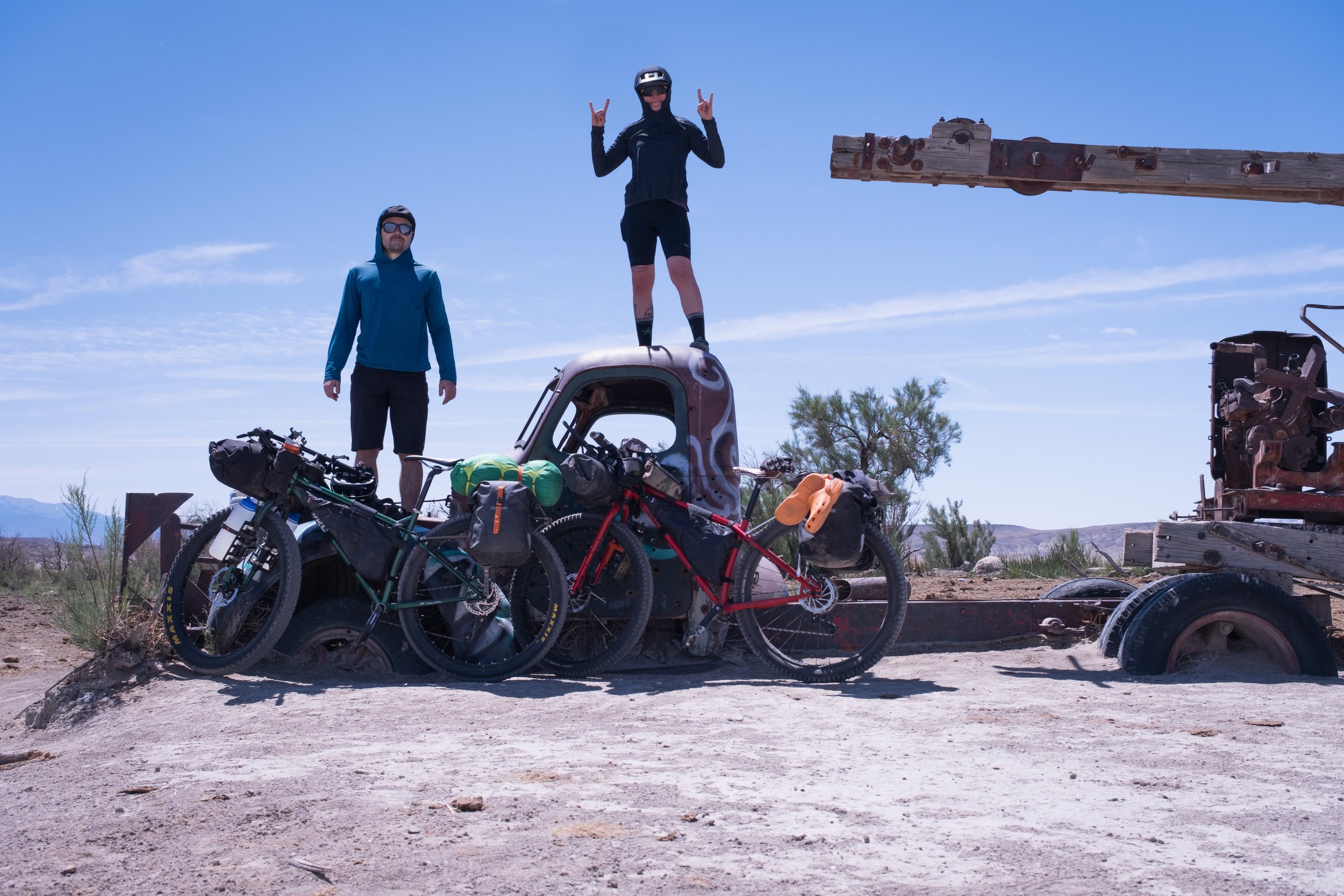
A mile in and we had to double up carrying our bikes across the Fremont River. At the time is was about knee deep and pretty cold but certainly a welcome relief from the sun. At least for a moment. An hour of riding through colourful bentonite hills we reach a plateau and continue on until we ride up on an old truck and some tired, rusted equipment full of bullet holes.

The overnight ride and the decision to road ride first meant day one would be longer than the following day returning to the car. It actually dragged on a little toward the late afternoon and somewhere around mile marker in the mid 40’s we rode up on the camp ground. Given our ability to be a little more flexible on camp site location we moved a little beyond the camp ground and worked our way up to the following spot which had an astoundingly beautiful view of Cathedral Valley below.


Iceland Divide
The last 4 hours or so a combination of unridable terrain and near unridable terrain but the route skirts the glacier and was incredibly beautiful and dramatic. After 12 hours on and off the bike I finally reached Kistufell, a little backcountry hut that feels a million miles from anywhere, from everywhere. It was incredible. The hut sits right on the North end of the Vatnajokull National Park. When I looked through the log book inside, the previous entry five days earlier mentioned the place looked like Tatooine.
Akureyri to Dyngjufell
I started riding south out of Akureyri on day one. Mostly on pavement, it was a short 50 mile day riding in sunshine. Stopping to camp south of Godafoss the rain started and didn’t stop until I got up to get going day two. Another reasonably easy day on the bike riding approximately 40 miles and gaining elevation up through farmland and into some desolate lava fields. Day three was shorter in distance but came with a significant headwind and challenging terrain. Navigating lava fields would be impossible without GPS. Even with GPS I find myself getting lost and completely disoriented dragging my bike up and over lava rocks to get back on track, of which there isn’t one. It’s a strange feeling hike-a-biking through lava fields when there doesn’t appear to be a clear route. It all looks the same. What you think is the right way turns out the be the way you came and the way you came turns out to be the direction you’re supposed to go. The shorter distance was certainly welcome but the lava fields were a significant challenge and seriously time consuming.

After about 12 hours on the bike I finally made it to Dyngjufell backcountry hut where I planned to sleep for the night. It was certainly welcome relief from the wind. I got to bed about 8pm knowing I had a really big day the following day - I was joined by three hikers at about 10pm. I spoke to them in the morning and we had a laugh about the weather and getting lost in the lava fields. Two men from Germany were planning to hike to Reykjavik and a woman from France was doing a four day loop and this was the furthest south she would be on her route. The two German blokes were struggling and their feet were really torn up. They had a huge hike ahead of them and this was just the beginning. Regardless they were in good spirits when I left early the following day although they spoke about how daunted they were by the task ahead. I too had similar thoughts but my body was healthy and I was feeling excited to get on the bike.

Positive thoughts flowed after enjoying catching up with some people and sharing stories from the trail. I set out early in the morning day four and had a couple river crossings to get things going. It was about knee deep and I was glad I opted to take off my shoes. It was a steady climb for the first five hours or so til I topped out at around midday. As soon as I reached the saddle and looked out across the moon-like landscape the wind smashed me in the face. It was so strong riding in to it was extremely difficult to make any real progress. Over the next handful of hours I would alternate between riding a short burst and pushing. Later in the day, seriously in the middle of nowhere a police truck crawled its way through the lava field I was navigating. Iceland’s interior terrain and weather is rough on just about everything, including motorized transport. Iceland’s trucks, the ones designed to travel in the highlands look more like monster trucks, huge wheels and everything. The police pull up and we talked about my route. I was informed that four trucks had been caught in a river and washed downstream and that my route needed to be adjusted because of the river crossing I would normally be able to walk across would be impassable.
Police intervention
Unfortunately the route the police suggested which would begin the following day was a hiking route only. I figured I would simply ride the hiking path but, given how remote this route is there is no path and the route is marked by wooden markers spaced about 50 meters apart.
A seriously tough day 4 with a lot of pushing. At one point during the day I couldn’t see the ground the wind was ripping sand across the landscape.
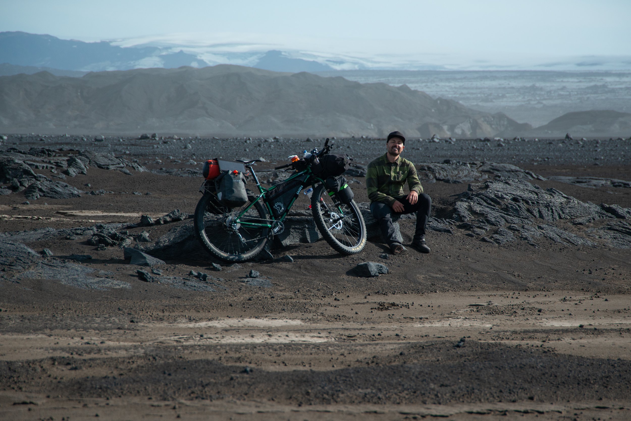
The last 4 hours or so a combination of unridable terrain and near unridable terrain but the route skirts the glacier and was incredibly beautiful and dramatic. After 12 hours on and off the bike I finally reached Kistufell, a little backcountry hut that feels a million miles from anywhere, from everywhere. It was incredible. The hut sits right on the North end of the Vatnajokull National Park. When I looked through the log book inside, the previous entry five days earlier mentioned the place looked like Tatooine.
Welcome progress

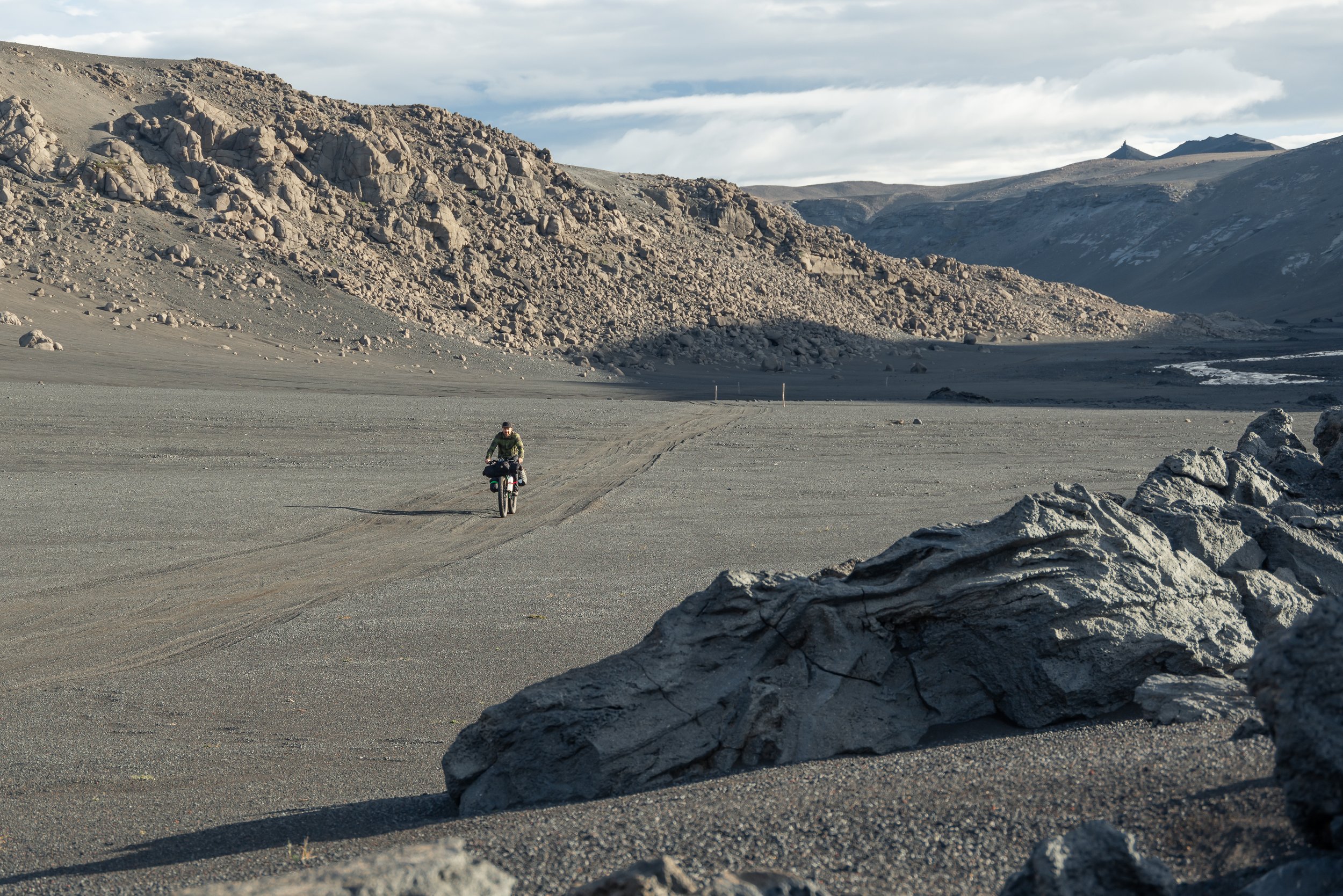
Up at 6am to try and beat the wind and the riding was great early morning Day 5. Boosted by the knowledge that Kistufell was the highest point on my ride I made good time and enjoyed working my way through glacial runoff, sandy flats and the odd lava field. A couple hours in and I started to descend here and there loving making good ground in perfect conditions. The views were spectacular as I skirted around Vatnajokull Glacier. I stopped for a little climb to grab a selfie on this volcanic rock jutting out of the ground. I was feeling great. I guess the arms out in a somewhat hug the world stance is a decent indicator.

About midday was where things took a turn. This is the point I was told to alter my route by the police. They said I must head directly south at the bridge instead of along the road. Originally it’s at this point where I join a jeep road and from here on out should make pretty good time as the road conditions are decent enough for your standard 4wd. The alternate route is a hiking trail which is about 10 miles longer, but as it isn’t marked on my map or my GPS I wasn’t aware of the vertical.

I was still in two minds about altering my route. But when I reached the bridge, at the time, it made sense. The river was moving along pretty good. The two options; Cross the bridge and take the hiking trail. Don’t cross the bridge, take the road and cross the river without a bridge about 8 miles down the road.

Things take a turn
Despite seeing the river it was a tough decision because I knew the hardest part of the ten days were supposed to be behind me and I would finally be on double track suitable for most cars albeit a little bumpy. The alternative however was an unknown.
About midday on day five I cross the bridge take the alternative and head directly in to the wind. It’s steady going, with a slight altitude gain. Over the next four hours the wind picks up. Loose sand blows across the desert floor as I switch between riding and pushing.
The trail forks and I head right and push up a steep incline for about an hour and reach a vast overlook. The hiking only trail in front of me is marked with little yellow wood markers every 50m or so.
The trail starts with a really steep slide/fall down a scree slope. I’m mostly dragging my bike with the brakes on as I slide down the slope. Once at the bottom, i’m met with an incredibly vast landscape, about a half km in glacial runoff makes its way downhill. When I reach it, the water is deep enough to warrant taking shoes and socks off. I cross, put shoes and socks on because it’s insanely cold, walk a short distance, take shoes and socks off, carry bike across the water, put shoes and socks on repeat.

About 9 hours in and finally, shoes and socks permanently on. Although my feet needed a wash anyway. But i’m back to pushing up hill. It wanders down and up for about another hour before becoming extremely steep and soft. The smell of sulphur is in the air and warm geothermal spring water runs down small canyons in the side of the mountain. Florescent algae and hyper green grass is an extremely odd contrast to the desert, moon-like landscape. The earth is soft and the climbing is really slow going. About two hours later I reach the saddle. I really hoped I would find a trail I could ride down and in to town. Unfortunately it couldn’t be further from it.
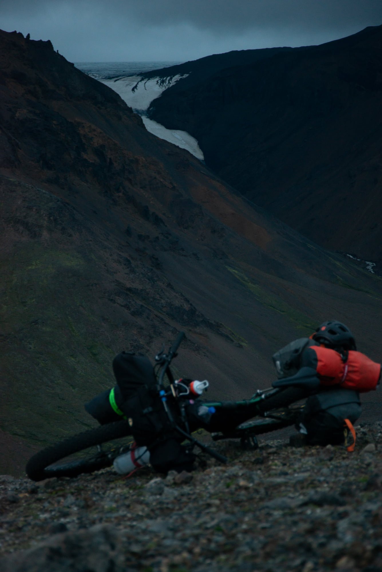
From the mountain pass looking over, wind rips up a massive canyon. I’m presented with a boulder field. What looks like a landslide or avalanche at one point is mostly car sized rocks. I carried my bike through the boulder field and on the far side was met with ice and snow. The cost of falling would be quite critical as the canyon drops away about 300m to my right. Without any option I make my way across the snow and ice. I lose the trail and spend a while finding the markers again but eventually do.
Back on a vague trail I continue along the top of this massive canyon as cloud moves in making visibility quite difficult. Being in the cloud makes it feel kinda like it is raining too. That really damp air type rain, without being rain.
As I continue the trail disappears and i’m back to navigating by the markers. The trail is constant, up and down, up and down right along the top of the canyon which drops away to the right into nothingness.
Light fades and the cloud gets thicker. I’m able to ride some walk some but it’s slow going. About fourteen hours in and it’s a real struggle to find the markers. I’m really keen to get off this mountain though so I push on hoping the trail will take me down sooner than later.
Battling for another two hours and it’s late, i’m completely in the cloud and seeing the next marker is impossible. I get lost on a number of occasions and end up walking around trying to find the marker I had come from to get my bearings again before trying to find the next one. Eventually I decide to leave my bike so I don’t have to drag that around on my marker search. I walk into the cloud and leave a large rock to find my way back. Find the next marker, go back, get my bike and push on to the next marker and repeat.
About 16.5 hours in this day and I decide it’s simply too dark and too dangerous to keep going. I set the tent up quickly eat something and get in. It’s so windy the tent is pressed against my face and it flaps incessantly. It’s raining and that soon presses through the fabric and on to me. My sleeping bag is wet, i’m wet and cold and I try to lie there and rest but the noise, the wet, the cold aren’t great for catching some z’s. I get up and put my wet weather gear on so now i’m wearing everything I have. I get back in my sleeping bag and try to get some sleep but it’s simply too cold and wet. I spend a number of hours shivering in my sleeping bag as rain turns to sleet.
Somewhere around 3ish, 4am shivering in my sleeping bag i’m thinking if I get any colder i’m going to have to get up and keep going even if it is still dark. Although I was really cold and wet, it wasn’t panic stations but if things got colder i’d have to make a move. About an hour or so later it was just light enough to pack up and get moving.
All packed up I was able to do some riding mixed with scree sliding to make my way down the mountain. A number of hours of this and the descent turns from scree to grass. Back on my bike riding, I spend a couple hours picking my way across the boggy grass with plenty of stream crossings thrown in.
Finally back on level ground and the markers direct me along the mountainside so much so my never ending headwind ends and for the first time in six days i’ve got a tailwind. The markers end and a sign marks the beginning / end of the trail and i’m joined up with the road I should have been on the previous day. Riding the road for a couple miles I find my way to the ranger station which was my destination for the previous night.
I lay down on the grass out the front and did a little thousand yard stare for I don’t know how long.
While I was spacing out on the grass, a group of motorbikers rolled through. There was about 20 or so of them and one of the blokes asked me how I was going. I said I was “alright, but a bit beat up.” He said “Yeah, you don’t look so good. Are you going south?” I said “That’s the plan, how is it?” He replied well, I just spoke to the ranger and weather is coming in and I don’t think it’s going to be possible. But head in and speak to the ranger and see what options you’ve got.”
I walked in to the rangers hut and an older woman with a big wool beanie on and long grey hair in two braids that ran down the front of her woolen cable knit sweater greeted me. She said she was expecting me as she had been in contact with the police. I guess I wasn’t looking my best and while she made me a hot chocolate she said she was amazed I had made it over on a bike. I told her no one should take that route on a bike and she certainly agreed and said she needed to ensure police weren’t sending people that way. Weather was coming in however and as it turns out she recommended that I stay there for at least two days for it to pass as they were expecting gale force winds. I was also asked about two Italian riders that were supposed to be in front of me but I had never seen them which seemed to worry her as she hadn’t either.
While I drank my hot chocolate, one of the guys from the motorbike crew came in and asked what my plan was. When I said I wasn’t too keen on waiting around for a couple days to see if the weather was going to improve he offered a ride north. They had a support truck I could ride in and although it’d be a days drive I could get myself out of a pretty tough spot. I decided to go with the motorbike crew and head north, putting an end to my north to south bike pack trip. Although I was really disappointed I felt like it was the right thing to do.

Bikepacking the Gallatin, Montana
It’s extremely dark when i’m woken by the loud bang of my bike being knocked over. I faintly hear rummaging around and soon after a rustling through the long grass right outside my shelter. My heart is beating so hard and although I was trying to be quiet, I swear I could hear my heart beating. As quietly as possible I reach my hand out of my sleeping bag and stretch toward my bear spray. I’m trying to regulate my breathing and at the same time hearing snorting and sniffing around just outside my shelter. I use my thumb to flick the plastic safety off the canister and I hold the bear spray at the ready for what seems like an eternity. The rustling eventually disappears and although i’m still on high alert, I eventually assume my visitor has left.
Late night visitor
Smoke blanketed Montana and northern Idaho from a fire three miles north of Bozeman burning 8000 acres in the Custer Gallatin National Forest. Heading north from Salt Lake City to Bozeman visibility was reduced to about a half mile. Strangely the thick smoke didn’t seem to smell much.
It was dark by the time I reached Bozeman. For a split second I thought I forgot my helmet. Then I remembered I did forget my helmet. I knew this trail wasn’t a walk in the park so I stopped by Target to pick one up and drove the final stretch to the trailhead.
Up early and I was greeted good morning by a dense array of conifers towering over the small car park. I loaded up and hit the trail. Early on there was some oncoming traffic but as the trail climbed through the forest rider numbers dwindled. Most of the morning was spent climbing. I clocked some decent miles and by the time lunch rolled around I had an opportunity to hang out by a huge lake. I stalled a little during lunch knowing I had about 5000ft to climb this afternoon.

The trail is relentless, loose gravel and rocks and there’s no reprieve from the ascent. My GPS reveals i’m climbing on a 14% grade. By the last 1000ft which is mostly above alpine, I resort to pushing but it’s not long before I reach the saddle at 9836ft. I stop for a selfie on the saddle before eyeing off the trail for the descent.
Descending through a handful of switchbacks off the top of the saddle the trail continues down in to some fast singletrack whipping through the forest. The sun threatens to disappear below the mountains as I continue down speeding up the process I decide to find an open area and setup for the night.
With approximately 15000ft of climbing total I packed light. My shelter doesn’t even have a floor. After setup and dinner I head to bed about 8pm and lay awake as the wind blows my shelter around and whistles through the surrounding trees but I eventually drift off.
It’s extremely dark when i’m woken by the loud bang of my bike being knocked over. I faintly hear rummaging around and soon after a rustling through the long grass right outside my shelter. My heart is beating so hard and although I was trying to be quiet, I swear I could hear my heart beating. As quietly as possible I reach my hand out of my sleeping bag and stretch toward my bear spray. I’m trying to regulate my breathing and at the same time hearing snorting and sniffing around just outside my shelter. I use my thumb to flick the plastic safety off the canister and I hold the bear spray at the ready for what seems like an eternity. The rustling eventually disappears and although i’m still on high alert, I eventually assume my visitor has left.
Climb time
Another day, another ridge. Day two saw me reach the top of Telephone Ridge. The way up, the trail winds through big healthy, densely populated pines. Although, this changed once I reached the top. From the ridge down into the valley below, burnt out pine tree skeletons defying gravity are littered across the landscape. Many still standing, many more unable to stay standing any longer. The zombie pine skeletons mixed with the smoky situation made for quite an eerie feeling.

It’s a rowdy descent down double track off the top of Telephone Ridge. It’s rutted, loose and plenty of dead trees cross the trail. Hard on the brakes I lose vertical rapidly before eventually bottoming out in the canyon. It feels like a day of climbing for minutes of downhill… and just like that, we’re on the climb again up to Hyalite Ridge.
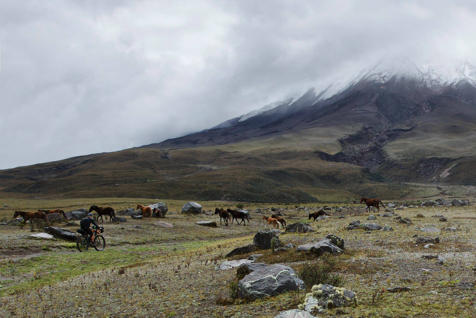
Bikepacking volcanos in Ecuador
I ride onwards and upwards, the climb is relentless and as the hours tick by the skies grow more and more angry. Huge storm clouds mill about overhead and i’m well aware of what this means. The climbing has really caught up with me and I develop a decent headache. Hopeful to make it to Cotopaxi by the end of the day as per my plan I push on, but my headache is throbbing and the skies start to rumble.
Empty farmhouses
As was the norm late afternoon I found myself looking for cover as rain set in and thunderstorms rolled through. Although rural, I was still in a reasonably populated area 40 kilometers or so from Quito. It was fairly easy to find a farm without any lights on to sneak in to for the night.
The next morning I got up early so as not to have any altercations with anyone for utilising a vacant farmhouse. So I headed up the road and found this roofless house in a small friendly village where every local seemed to go out of their way to say good morning.
I had a dehydrated breakfast skillet which only needed boiling water. While I waited for the water to boil, locals walked by making their way to their designated pickup spots for work. All of them had in their hands either a pickaxe and or a hand plough. A few wandered over for a chat and asked me about my bike while another squeezed the tyres and another bloke asked me how much a bike like this costs. They were pretty stoked with the push button ignition on my camping stove too.
A truck rolls in during our conversation, hits the horn and everyone piles in the back. They all seemed pretty happy to be heading off to plough fields, and they wished me "buen provecho" waving from the back of the truck. Not long after the truck left, 8 or so horses wandered down the road and had a look into the grass right in front of me. It was obviously not ideal grass as most of them took off except one grey horse. I setup a quick photo to get the horse and me in the shot but he wandered out of the photo. So this is a photo of me, watching a grey horse walk out of the frame.

After my chat with some friends, answering questions as best I could in Spanish and all packed up I hit the road. For some reason the road was cobblestone so it was bumpy going for the first couple hours. Beyond the cobblestone and into some remote farmland the road just continues to climb and climb. I pass by some farmers from time to time and ask to pass as per my guidebook and they wave me on.
Eventually I reach a fence with a locked gate it’s simply too high to lift my bike over and it’s too low to be passed under so after some thought, I jump the fence and head off looking for someone to help unlock the gate. It’s not long before I find two women milking cows and as best I can I ask to pass. They talk among themselves for what seems to be a very long time but eventually they both look at me with smiles on their face and say “three dollars”. It seemed like a reasonable deal, I paid and they opened up the gate.
I ride onwards and upwards, the climb is relentless and as the hours tick by the skies grow more and more angry. Huge storm clouds mill about overhead and i’m well aware of what this means. The climbing has really caught up with me and I develop a decent headache. Hopeful to make it to Cotopaxi by the end of the day as per my plan I push on, but my headache is throbbing and the skies start to rumble.
Tent poles and lightning
Rain begins to fall, my head is banging and the clouds swirl and rumble around me and overhead. I do my best to ride til I find some sort of cover and do so by jumping down a rock wall and nearby a stream. I setup my ultralight shelter next to this stream as I also needed water. Of course, my ultralight shelter doesn't have a floor so as rain turned to sleet and then to hail the amount of water running under and through my shelter was essentially a stream itself. I dragged my bike half underneath the shelter and stacked all my gear on top of my wheels to prevent them from getting wet. I had to hold the shelter down at the sides to prevent it from blowing away. As I did so, the hail was hammering down so hard it was difficult to hold the shelter. It’s difficult to communicate the level of migraine I was experiencing at the time. One that makes it difficult to see, difficult to move, difficult to think straight, difficult to manage myself in a storm so violent and so far beyond anything i’ve experienced before.
As the hail and sleet came down, constant body shaking thunder ripped through me. The loudest, scariest thunder i've ever experienced, and although the thunder was scary loud it was the lightning, which seemed to be constant, was the most concerning aspect of this storm. I was obviously in a little ultralight shelter, with a single metal pole trying its best to stay upright and a steel bike next to me. I stayed crouched down holding the sides of my shelter down with water streaming through my shelter for about 5 hours that late afternoon and into the night. The hail, rain, sleet, thunder and lightning didn't let up the entire time.
I had run out of water earlier in the day and chose this little spot next to the stream because the water was nice and clear and accessible. I did have to lift my bike over a rock wall to get to it however. Just as the final moments of day turned to night, I arose from the shelter and planned to head down to the stream to filter some water. The stream was no longer a cute little, clear water high altitude stream running off from snow melt on Cotopaxi. It was not a raging torrent of rich reddish brown sludge threatening to break its banks. I realised now the rock wall I had to jump over to get to my camping spot was a retaining wall to stop water from washing away the road at times like this. I was so tired I filtered some of the sludge, ate, drank and setup my bed and fell into my sleeping bag as the rain continued to hammer down. It was hard initially to sleep because I thought if I don't get electrocuted there's a fair chance i'll be washed away and or drown. I had a couple amusing conversations with myself at that moment; about how it would be funny story to drown on a bike riding trip while camping at 4200m; and that I sat next to a steel bicycle during an electrical storm for 5 hours and got electrocuted. Funny self talk and all, I guess I was so tired exhaustion overwhelmed me and I fell asleep.

I woke up early after the electrical storm from the day/night before. The "stream" was still a reddish brown but had backed off from the raging torrent it was the day before. There were glimpses of blue in the sky and I took a couple quick photos of Cotopaxi before packing up. Although my map suggested I was close, visibility the day before was so low I had no visual proof Cotopaxi was towering over me. This one is taken mid morning as I ride with some wild horses and clouds once again move in and cover the higher elevations of Cotopaxi.

Altiplano bikepacking Chile
I started out the day at 4300m and struggled with the altitude. Even some of the smaller climbs were real lung burners and my legs sometimes felt tingly. As I approached Misitune about 30kms in I felt better and better. I got used the constant burn and ongoing inability to catch my breath and worked with it.
Misitune and the burn
Lunch stop on day one in the abandoned stone village of Misitune. The view from where I was sitting overlooks a marsh where fifty or more vicunas and maybe a hundred or so flamingos were hanging out.
I started out the day at 4300m and struggled with the altitude. Even some of the smaller climbs were real lung burners and my legs sometimes felt tingly. As I approached Misitune about 30kms in I felt better and better. I got used the constant burn and ongoing inability to catch my breath and worked with it.

Reserva Nacional Las Vicuñas
I often wondered if it was worth hauling my heavy camera gear and tripod around on my handlebars. I especially wondered on the afternoon this photo was taken. I decided to take an alternative route to the one suggested on my map named "unnamed path". The path passed between Cerro Arintica 5550m and Cerro Puquintica 5750m. Although “unnamed path” was a small dotted line on the map, in my mind it was an untouched pristine singletrack making it’s way through two towering mountains and winding it’s way down to the valley floor. This was going to be the most epic, remote singletrack ever ridden.

Earlier in the day I came across a shack made out of mud blocks and political signs from yesteryear. I had heard the two women that lived there sold soup so I stopped in to check it out. They dished up llama soup with potatoes which was really tasty. I will say I didn't get a great cut of llama but the little meat that was in the soup had a similar taste to lamb, if not a little stronger. Speaking to one of the ladies they asked where I was headed. I let them know my plan to ride between the mountains and pointed up at them. She shook her head and made a shhh'ing sound and told me they were very big. I thought it was funny coming from a women that lives at about 4200m on Chile's Altiplano. I decided that I could take on the mountains anyway despite all the shhh'ing.
Later in the day I came across my turnoff to unnamed path. The path was sort of a path to begin with although I lost the trail twice in the first half a km or so. The trail then disappears and the terrain is steep and rocky. From there it was a matter of pushing uphill and lifting the bike over big rocks and pushing through soft sand. About 4 or 5 kms and 2 hours of climbing later I arrived at this flat section between the two mountains and decided, given the sun was setting that this was where i'd setup for the night at about 4700m.
I was hungry and tired but I told myself you just dragged a bike and heavy camera gear up to this amazing spot, you might as well make the most of it as the sun lit up the upper section of Cerro Puquintica.